
 Topography
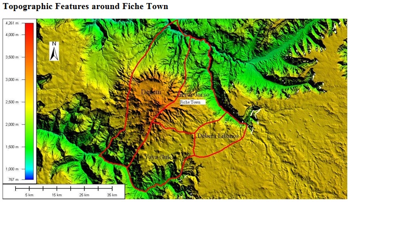
The
hinterland of Fiche town is part and parcel of the northern mountains. The
hinterland is characterized by dissected high plateaus and mountains associated
with hills, valleys and gorges. The lowest point is located in Abay gorge i.e.
1000 m.a.s.l. Peak points in the hinterland include Cheleleka (3,571m), Gara
Guda (3,544m), Intoto (3,211),) and Elen are the major mountains even in the
zone.

 The
topographic features of hinterland influence the physical characteristics like
climate that provides for the existence of different micro-climates due to
variation in elevation. This contributes for the presence of different natural
vegetation, soils and hence contributes for the presence of different
agro-climatic zones.
The
topographic features of hinterland influence the physical characteristics like
climate that provides for the existence of different micro-climates due to
variation in elevation. This contributes for the presence of different natural
vegetation, soils and hence contributes for the presence of different
agro-climatic zones.
Landscape
The
major landscapes of the hinterland which are the result of internal and
external forces include foot slopes/piedmont plains, plains, plateaus, and
mountains. The dominant landscape in the hinterland is valley and followed by
foot slopes or piedmont plains. The landscape of the planning town-Fiche is
characterized by foot slopes or piedmont plains this means the town is located
at the base of mountain ranges in north and northeast which is part and parcel
of the northern mountains of Ethiopia. From these highlands there are many
streams or small rivers commenced and flow towards the town and they are good
sources of water for domestic uses.
However, in case of high and continuous rainfall the town and the
surrounding area have a probability of inundated by flood. Therefore, good
watershed management is required to avoid flooding risks in Fiche town.
No comments:
Post a Comment